Skip to main content Skip to navigation

UKRI GCRF: Understanding Risks & Building Enhanced Capabilities in Latin American Cities

URBE Latam seeks to expand and refine the understanding of risks, vulnerabilities and potentialities associated with rain-related geohazards in Latin America.

URBE Latam aims to rethink how environmental risk data is produced, how it is used, and how it might enable transformations that close the implementation gap in delivering equitable resilience for marginalised communities. The project will be based on two case studies focusing on specific areas of Rio Janeiro, Brazil and Medellín, Colombia; however, the findings and methods developed during the research will be widely transferable to other places and environmental contexts.

This project is funded by a UKRI Collective Fund Award.

Background and Context

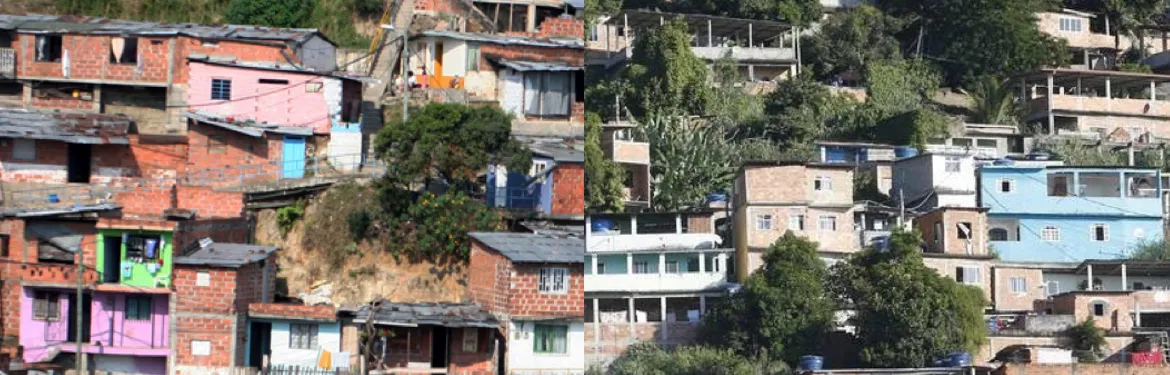
Poor urban neighbourhoods in Latin America frequently experience events such as landslides due to heavy rain. In 2011, for example, floods, landslides and mudslides in the state of Rio de Janeiro resulted in 903 deaths and over 2,900 people had their homes destroyed. Similarly, in the Colombian city of Medellín, accelerated urban growth since the 1950s has given rise to settlements on land exposed to hazards, significantly increasing landslide risk among low-income populations. In both cases, and across many developing countries, recently built settlements growing up steep hillsides are particularly exposed to landslide impacts. The situation in both of these major Latin American cities demonstrates the urgent need to improve the resilience of such communities against rainfall-related geohazards. Latin America has undergone accelerated urban growth in the past 50 years and it is presently one of the most urbanised areas of the world. One consequence of this trend is the proliferation of marginalised urban neighbourhoods which are not only disproportionately exposed to natural hazards, but also have less economic and social capital to adapt and respond to their consequences.

This has led to a number of initiatives designed to anticipate and manage risk more effectively so as to reduce the impact of disasters. However, a noticeable implementation gap in the delivery of equitable resilience is evident. This is not only attributable to a lack of resources, but also to highly complex social, economic, political and institutional reasons.

Our Approach

The highly skilled, multi-disciplinary research team will adopt a dialogic co-production approach to citizen-generated data that relies upon well-established partnerships with community-based initiatives for local development, education and disaster risk reduction in Rio de Janeiro and Medellín, and with governmental agencies involved in disaster risk reduction and local planning and development.

Research Objectives

URBE Latam seeks to expand and refine the understanding of risks, vulnerabilities and potentialities associated with rain-related geohazards in Latin America by rethinking how environmental risk data is produced, how it is used, and how it might enable transformations that close the implementation gap in delivering equitable resilience for marginalised communities. The project will be based on two case studies focusing on specific areas of Rio Janeiro, Brazil and Medellín, Colombia; however, the findings and methods developed during the research will be widely transferable to other places and environmental contexts.

This overarching goal will be achieved through the pursuit of five main objectives:

  1. Dialogically engage citizens in marginalised communities to promote awareness and generate data about local vulnerabilities and potentialities.
  2. Develop a digital platform and mobile app that will underpin the processing and analysis of the data produced by the citizen engagement programme.
  3. Understand the ways in which local government authorities, and other agencies involved in the management of environmental risk, currently collect and monitor data to enhance resilience.
  4. Integrate the new forms citizen-generated data with conventional data sources to recalibrate risk management practices, in ways that enable pathways for transition to sustainable development whilst also supporting more equitable decision-making and policy-making on development and resilience.
  5. Develop and promote communication and knowledge exchange between stakeholders of various agencies - both governmental and non-governmental - that are currently working to improve local development of marginalised neighbourhoods in these major Latin American cities and their resilience to rain-related geohazards.

Project Dates

URBE Latam: Understanding Risks and Building Enhanced Capabilities in Latin American cities

Start date 01.11.19

End Date: 30.10.2022

Work Package 1 : Engaging citizens to expand understandings of risks, vulnerabilities and potentialities

Partners involved : Federal University of Rio de Janeiro, CPCD, e-Dinheiro, Institución Universitaria Colegio Mayor de Antioquia

This project work package adopts digital engagement methods which combine digital mapping and community-based research methodologies to create a mobile application and a digital platform. The aim of this will be to expand the understanding of risks and vulnerabilities faced by people living in disaster prone areas.The project team will combine sociotechnical approaches to software development (Cukierman, 2018) participatory mapping (de Albuquerque et al. 2019) and innovative methods for community engagement to achieve the project objectives.

The following describes the tasks, timescale and deliverables associated with Work Package 1:

  • Year 1 will see the project team begin to map aspects of physical vulnerability (e.g. fragility of buildings) and human vulnerability such as exposure, resistance and resilience (Pelling, 2003), which will be further specified project through the insights yielded by communities’ perspectives and environmental risk mapping (WP3). Project partners will design a mobile application and collaborative digital platform. This will be done in collaboration with the software development teams of CPCD and DataLabe, a grassroots NGO of young residents of the deprived neighbourhood of Favela da Maré in Rio de Janeiro, who will contribute to testing and validating the digital platform
  • Year 2 will focus on citizen-generated data for understanding the concrete reality of people living in the at-risk urban poor neighbourhoods of our study areas Morro do Preventório and El Pacifico and their relation to environmental hazards. Engagement exercises will not only produce co-constructed vulnerability maps with high spatial granularity, but also shared learning and critical consciousness about issues faced by communities and their development potentialities.
  • Year 3, we will generate an article on the digital engagement method and co-create recommendations of opportunities to implement community-based innovations that combine risk reduction and development, with inputs from the community-based landslide risk reduction strategies of WP3 and aligned with the opportunities for local development and micro-credit investment identified.

Work Package 2 : Analysing socio-spatial inequalities in urban resilience and sustainable development governance

Partners involved : University of Warwick, CEMADEN, Federal University of Rio de Janeiro, and Institución Universitaria Colegio Mayor de Antioquia

The focus in this work package is to identify the framing of risk, resilience and development and assess the implications on the worldviews represented therein. This will be undertaken by producing a report on the current data practices of risk management and SDG 11 monitoring and reporting, at city and national level in Rio and Medellín. Particular attention will be paid to the extent to which conceptualisations, categorisations, datasets and data generation methods are likely to perpetuate socio-spatial inequalities – or, in other words, to their socio-spatial inclusiveness.

The following describes the tasks,timescale and deliverables associated with Work Package 2:

  • Year 1: The project team will seek a greater understanding of what and whose data about risks is used, how and by whom it is transformed and interpreted, as well as about the degree of rights and entitlements to physical and social “capabilities to achieve well-being goals” (Ziervogel et al., 2017: 124). This is essential for drawing conclusions regarding the extent to which conceptual alignment is implemented in practice and intra-urban inequalities are accounted for. It will also reveal how different institutional actors deal with issues and how data is used to frame risk and its relation to urban inequalities. To collect such data, we will conduct interviews with institutional actors currently engaged in environmental risk management and urban development in the two cities and conduct observations of data practices, workflow, and document analysis with our partners (CPRM, Cemaden, DAGRD, SIATA).
  • Year 2: We will use the data collected as a basis for a systematic contrast with the results from citizen-generated data of WP1. A key output for this phase of the project is to produce an article that identifies gaps, misalignments and inequalities in current risk management and urban development practices.
  • Year 3 : we will organise workshops with partners to co-create recommendations for policy and practice as to how to make urban resilience and development governance mechanisms better aligned and more socio-spatially inclusive.

Work Package 3 : Recalibrating environmental risk mapping

Partners involved : : Universidad de Antioquia, British Geological Survey, Institución Universitaria Colegio Mayor de Antioquia, and Geological Survey of Brazil

The following describes the tasks,timescale and deliverables associated with Work Package 3:

  • Year 1: It will start with a comparative assessment of current methods and data used for landslide risk assessment and monitoring in Brazil, Colombia and the UK, investigating the possibility of generating enhanced susceptibility maps that combine available official data with remote sensing data. This would enable landslide hazard areas to be identified more precisely, and would include complementary environmental features that can be provided from citizen-generated data.
  • Year 2: Informed by the data practices uncovered in WP1 & 2, we will build upon our previous work (Restrepo-Estrada et al. 2018) to develop an approach to assimilate the citizen-generated data produced as part of WP1, integrating them with socioeconomic and landslide data to generate new and more locally contextual exposure maps.
  • Year 3, WP3 will identify potential for co-designed community-based landslide risk reduction strategies, informed by the approach developed by the MoSSaiC project which developed a framework for reducing landslide risks affecting communities and infrastructure now adopted by the World Bank in disaster risk mitigation projects more widely in Latin America and the Caribbean. Key risk reduction strategies in MoSSaiC included reducing the amount of water infiltrating into slopes through the creation of a network of surface drains linked to household roof and grey water drainage systems. We will identify key locations where community-based risk reduction strategies would be most beneficial based on the data produced in WP1 and WP3, and investigate how aspects of the MoSSaiC framework and associated methodologies could be relevant to the two case study areas. WP3 researchers will explore the application of the practical solutions implemented on the basis of the MoSSaiC research, which will be used as a basis for co-designing recommendations for community-based landslide risk reduction by our local partners of WP1 together with members of the communities


Work Package 4: Facilitating Dialogic Transformations to Equitable Resilience
Project Partners Involved: University of Warwick, Federal University of Rio de Janeiro, Universidad de Antioquia, Institución Universitaria Colegio Mayor de Antioquia, CEMADEN, British Geological Survey, and Geological Survey of Brazil.

WP4 aims to develop a framework to track and facilitate dialogic transformations based on interactions within and outside the project consortium. This will consist of establishing and implementing a monitoring, evaluation and learning framework, including a baseline assessment as regards to key impact indicators in Year 1. In Years 2 and 3, alongside annual project meetings (in Brazil, Colombia and UK), a series of dialogic transformation workshops will be organised, which consist of dedicated learning moments to ensure that the co-produced research results can be directly and thoughtfully incorporated into transformations of the practices of key stakeholders, and to promote knowledge co-production with members of the community and beyond. Transformation workshops will be structured so as to first present ongoing findings (diagnostic phase); secondly, to facilitate creative thinking about current and future resilience practices (creative or dream phase); and thirdly, to advance ideas and principles that might be taken into practice situations (challenge or operational phase).

At the end of each workshop, researchers in collaboration with stakeholders will produce a written recommendation for how best to achieve organisational transformation through improved practices. While the written recommendations will be valuable for reaching out to non-participants, we also consider participation in the workshops themselves as avenues for transformation. Furthermore, based on the final project evaluation, the academic leads of WP4 will collaborate with UN Habitat to produce evidence-based methodological guidelines for obtaining a co-produced and broadened understanding of risk that can be systematically incorporated into SDG monitoring. This will be targeted at organisations responsible for SDG progress monitoring and implementation such as national governments. The guidelines and key project results will be disseminated in a workshop with wider stakeholders and policy makers in both development and risk management and policy making Therefore, through additional international comparisons and engagement of a wider set of policymakers and macro-regional stakeholders on disaster risk management and international development, we will extend the impact and generalisability of our project results.


SDG11

SDG 11: Sustainable Cities and Communities

The expected long-term impact of this project is a contribution towards the SDG 11 targets of:

  • reducing the number of deaths and people affected by water-related disasters and reducing direct economic losses caused (SDG 11.5)
  • increasing the number of cities and human settlements adopting integrated policies and plans towards resilience to disasters and holistic disaster risk management (SDG 11.B).

Project Partners

BGS logoCOPPE UFRJ Colegio Mayor Logo Cemaden Logo CPRM Logo UdeA Logo

This is a UKRI Collective Fund Award.
GCRF logoUKRI Logo