Mapping the Global Imaginary, 1500-1900: Subsistence Agriculture and Estate Plans in the Early Modern Caribbean
Published 5 April 2019 - Bertie Mandelblatt and Kären Wigen
On 14-15 February 2019, the Warwick GHCC and Stanford University hosted a conference on 'Mapping the Global Imaginary, 1500-1900' at The David Rumsey Map Center. In this guest blog, Professor Kären Wigen (Stanford) explains how the items on display during the conference frame our discussions of early modern cartography, after which Dr Bertie Mandelblatt (John Carter Brown Library) illustrates her research on subsistence agriculture and the American plantation economy by focusing on an eighteenth-century estate plan produced in the French colony of Saint Domingue.
Mapping the Global Imaginary, 1500-1900 – Kären Wigen
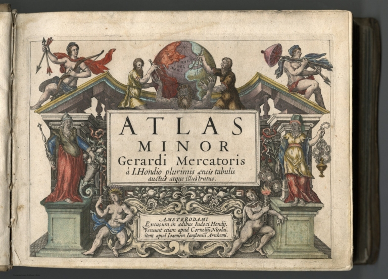
Map-making and map reading are deeply imaginative acts. The items on display during the Warwick-Stanford ‘Mapping the Global Imaginary, 1500-1900’ conference at the David Rumsey Map Center highlighted some of the principal ways in which the human imagination was summoned into play by cartographers in the early modern period.
To start, some of the cases highlighted a challenge faced by those working on a global scale during the sixteenth and seventeenth centuries: namely, the fact that big swaths of the world remained terra incognita. European cartographers responded in different ways to this problem. If some filled in the blank spaces with speculative geography, others deliberately left their outlines open-ended to add data as it came in.
Those who confined themselves to more local terrain had less scope for fancy, or so one might think. But even in small-area maps that hone in on a single plantation or town, a range of visual and narrative strategies can be seen at work, embellishing some elements while shrinking others (or omitting them altogether).
Other cases offered a glimpse into how later map designers at both ends of Eurasia pushed their art in novel directions. In the far West, some cartographers taxed their skill to conjure the earth as a three-dimensional sphere, spinning through space and replete with moving waters and winds. In the far East, meanwhile, other artists—steeped in Asian religious and literary traditions—found ways to embed resonant place-names from poetry and legend into maps that were simultaneously crowded with mundane toponyms.
The final set of items concerned a remarkable collection of touristic and “sentimental” maps of Africa and South America, including a hand-drawn map by Bramwell Brontë. Saturated with racial stereotypes and imperial hubris, these innocent-looking materials remind us of the long cartographic shadow cast by early modern imperialism.
Written on the Map: Subsistence Agriculture and Estate Plans in the early modern Caribbean – Bertie Mandelblatt
European plantations across the tropical zones of the Americas were concrete sites of the intersection of highly individualized indigenous ecologies with new globalizing economies of export commodity production. English, French, Spanish, Portuguese and Dutch planters manipulated landscapes on islands in the Caribbean and on both northern and southern mainlands to create agricultural plantations whose main focus was the production of crops for transatlantic export, such as tobacco, sugar, indigo and coffee. These plantations entered the cartographic record in many ways, amongst them through the evolution of the genre of the estate plan.
As a cartographic genre, the estate plan both illustrates and embodies how land became identified and represented in terms of its economic yield to its owner.[1] It unites the graphic representation of territory with the social and economic contexts in which these new territorial units took form, and, for this reason, estate plans are particularly well adapted to recording an often-unremarked aspect of plantation political economy: subsistence agriculture. An adequate and stable food supply for both free and, more importantly, unfree colonial populations continued to be a crisis throughout the colonial period of plantation America, to which a variety of long- and short-term, global and local solutions were sought but never successfully instituted.[2]
Analyses of estate plans reveal the primordial importance of this understudied aspect of plantation economies through the institutionalization of provisions grounds and gardens of different varieties.
The example of a relatively recent acquisition of the John Carter Brown Library is a powerful and visually arresting piece of graphic evidence that bears out the capacity of estates plans to reveal the social and agricultural world often absent from formal, smaller-scale maps of islands, colonies or empires drawn and printed in this period. The 1775 Plan géometrique de l'habitation de Mr. Guilleaume François Vallée by Mancel forcefully underlines the nature of a certain kind of plantation management in Saint Domingue during the decades after the Seven Years’ War (1763) and before the outbreak of the Haitian Revolution in 1791, emphasizing and clarifying the role of subsistence agriculture.[3]
This hand-coloured, linen-backed manuscript map [Figure 1] is the work of Mancel, a royal surveyor, who was working between the 1750s and 1780s in Jérémie, on the northern coast of the southern peninsula of Saint Domingue, the French colony located in the western third of the island of Hispaniola that in this postwar period was entering into its period of explosive growth.[4]
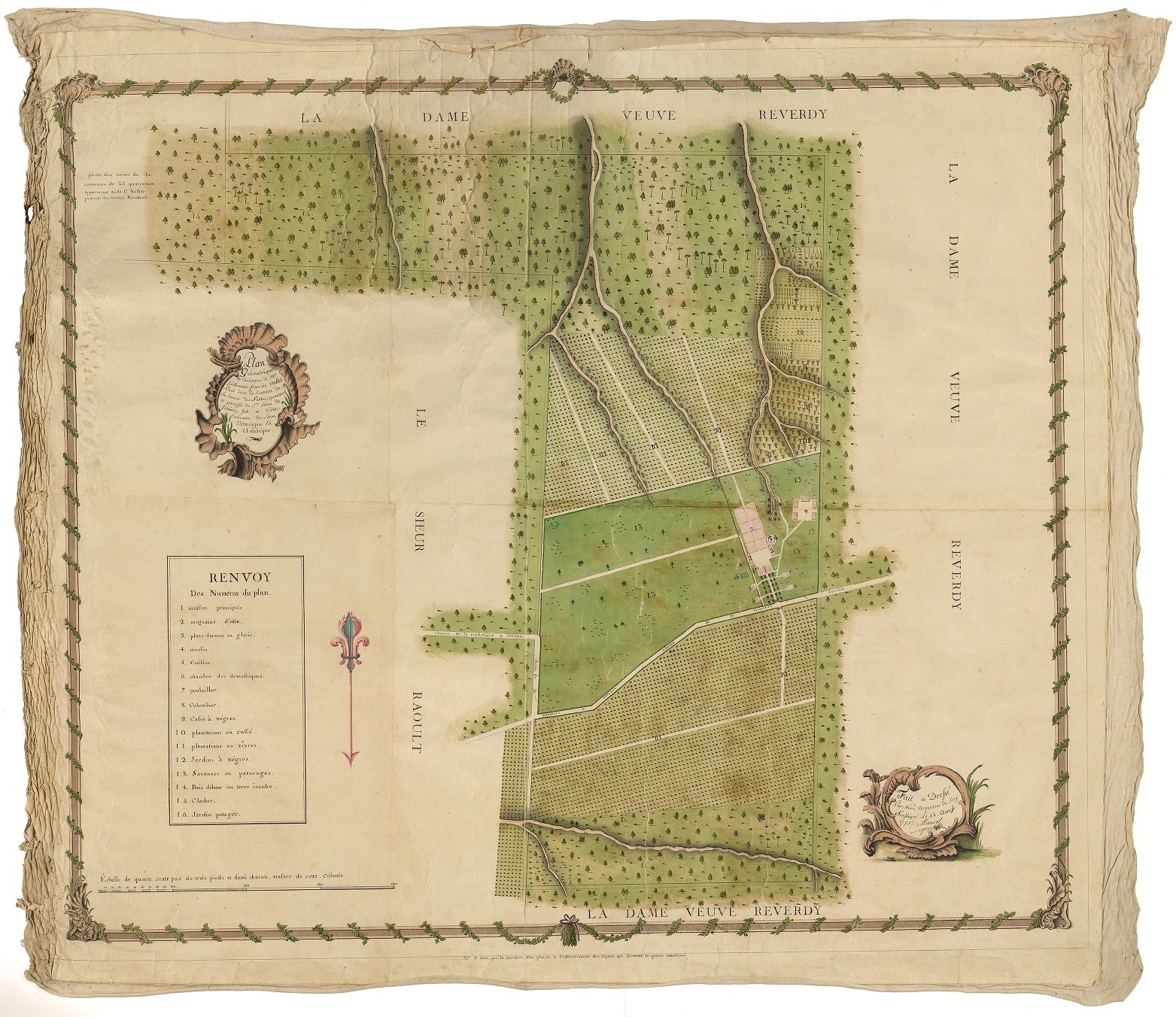 Mancel, Plan géometrique de l'habitation de Mr. Guilleaume François Vallée, située dans les hauteurs de la ravine des Sables, quartier et paroisse de St. Louis de Jérémie, isle et côte française de Saint Domingue en Amérique, 1775. John Carter Brown Library, 14-178.
The estate plan represents in meticulous detail the landholdings of M. Guillaume François Vallée, located, as Mancel specifies in the cartouche, on the higher reaches of the Ravine des Sables, in the parish of St. Louis de Jérémie. The landholdings contain carefully differentiated plots within the boundaries established by the estate plan, all of which are described in a key: prime amongst them are the coffee plantations that are the main commercial crop being cultivated, but there are also ‘Bois Debout ou terre inculte’ (uncultivated land and land containing standing timber) and a substantial amount of grazing land.
The plan also bears unique testimony to the social lives of the plantation residents, both free and unfree, through its depiction of subsistence agriculture and livestock raising. Very unusually, three separate plots of land are designated as plots where subsistence crops were grown. One large plot named ‘jardins à nègres’ (#12 in the key) clearly corresponds to the provision grounds in which enslaved plantation residents were able to grow crops for their own subsistence: the crops within these plots are graphically differentiated from each other: Mancel distinguishes at least 4 or 5 different crops, one of which resembles a banana or plantain tree. This large plot is the cultivated land located furthest away from the plantation residential complex: slaves’ dwellings (#9) are grouped together off-centre and away from the symmetrical arrangement of the planter’s house (#1) and two side storehouses (#2).
Located closer to the residential complex, however, are three grouped-together smaller plots (all #11) that are also designated ‘plantations à vivres’ – subsistence crop plantations. These plots were most likely devoted to growing subsistence crops that would be sold or bartered locally, regionally, or enter the intra- and inter-island trades in subsistence foods. While there is very little direct primary research on these trades and how they operated, there is much evidence that points both to their existence and to their importance in the survival of the colony, in which a stable food supply remained a crisis for the entirety of its existence. It is exactly this kind of agricultural diversification for which coffee plantations on the southern peninsula were so well known, and this map provides crucial evidence for it.[5]
Moreover, the mapmaker has depicted only a single crop cultivated in these plots (banana/plantain?) which increases the likelihood that this crop would have been destined for sale or exchange. In addition to these depictions of subsistence agriculture, the map depicts a third site of the cultivation of food crops: a very small ‘jardin potager’ close to the residential complex that would have grown crops for the planter’s table. Finally, also close to the residential complex, we see the plantation kitchen, and both a dovecote and a poulailler,where fowl would have been raised. Mancel’s estate plan of Vallée’s landholding provides a rich source of primary data that allows us to reconstruct the spatial history of subsistence agriculture in the colony of Saint Domingue during this period of the intensification of export agriculture. The estate plan reveals and indeed establishes what many textual accounts occlude: the land use patterns and informal economies brought into being by the everyday lives of free plantation residents, but also – and more importantly - those of enslaved workers and other enslaved plantation residents.
In conclusion, the representation of subsistence agriculture in this estate plan provides a direct link to the social lives of plantation labour through the symbolic representation of the agricultural potential of plantation land. In some senses it betrays the colonial fantasies of the surveyors, cartographers and land-owning estate planners who lay behind the production of these cartographic works whose main concern was often as in creating highly aestheticized graphic documents that celebrated ownership of and mastery over land as it was to visualize land parcels in order to manage production more efficiently. Ultimately, these representations of subsistence agriculture connect us both to the material realities of the territories that were in the midst of such dramatic transformation in the context of radical European ambitions to establish commercially successful export agriculture, and to the multitude of historical actors who were both essential to these undertakings and absent from the pictures.
Dr Bertie Mandelblatt is a historical geographer of the early modern Atlantic world (PhD, University of London, 2008) and the George S. Parker II '51 Curator of Maps and Prints at the John Carter Brown Library in Providence, Rhode Island. She is currently finishing a book in which she reconstructs the contested histories of subsistence, food provision and food consumption in the French Caribbean in the colonial period. Her new research project concerns the cartographic history of independent economic activity in the colonial Caribbean, ranging from the sixteenth to the eighteenth centuries, in which she seeks to understand how early modern maps at multiple scales reflect the multi-vocal nature of the act of compiling spatial information endemic to cartographic creation. That is, how these maps contain the graphic traces of how indigenous and enslaved people sought to exist outside and within the plantation system.
[1]David Buisseret, “Introduction,” in Rural Images: Estate Mapsin the Old and New Worlds, David Buisseret, ed. (Chicago: The University of Chicago Press, 1996), p. 1-2.
[2]Bertie Mandelblatt, “'A Land where Hunger is in Gold and Famine is in Opulence’: Plantation Slavery, Island Ecology, and the Fear of Famine in the French Caribbean,” in Fear and the Shaping of Early Modern American Societies, Lauric Henneton and L.H. Roper, eds., Brill, 2016, p. 243-254.
[3]https://jcb.lunaimaging.com/luna/servlet/s/93su3i. The catalogue record for this map is here: http://josiah.brown.edu/record=b7319275~S7
[4]See also: https://gallica.bnf.fr/ark:/12148/btv1b8492214w and https://catalogue.bnf.fr/ark:/12148/cb40665300s
[5]A classic account of coffee cultivation in Saint Domingue is Michel-Rolph Trouillot, “Coffee Planters and Coffee Slaves in the Antilles: The Impact of a Secondary Crop,” in Ira Berlin and Philip D. Morgan (eds.), Cultivation and Culture: Labor and the Shaping of Slave Life in the Americas (Charlottesville and London: University of Virginia Press, 1993), p. 124-137.