Unmanned Aerial Inspection Vehicle - News
In the news!
The project had a short mention in a news article in the North West Evening Mail!
Progress on Autonomy
In this video one of my friends with no RC experience is in full control of the Hexakopter UAV with only about 10 minutes training.
Even though he is controlling it, the Hexakopter is flying itself maintaining any height and position commands given to it. Making it very easy to fly.
Download the video: Full HD (1080p AVCHD) or Standard Definition (WMV).
XSens Case Study
XSens, the manufacturers of the orientation sensor used on-board the UAV are using this project as one of their application case studies!
Check out the article on their website: http://www.xsens.com/en/industrial-applications/aerospace/warwick-mobile-robotics-hexakopter
Another 3D Mapping Video...
A video showing the hexakopter mapping a workshop hall at the MTC and what can be done with the data afterwards.
Download the video: Full HD (1080p MP4) or Standard Definition (WMV).
Poster
Not only can it hover... it moves!
The UAV is no longer stuck in the hover!
The video below shows the hexakopter taking-off moving 1 metre forwards and then moving back to the starting point and landing. The two yellow markers are 1m apart.
Download the video: Full HD (1080p MP4) or Standard definition (WMV)
I will hopefully be able to get a video of it flying a square pattern and not just forwards and backwards shortly.
3D Mapping Video
This is a video I made last week demonstrating the current mapping capabilities of the hexacopter.
To download the higher quality video click here (WMV format)
Fully Autonomous Flight!!!
Yesterday the helicopter had its first fully autonomous flight!
At the moment it will (without me touching the controls) take off, climb to a set height and then hover on the spot before landing safely.
The only input required from me is to switch the motors on, a command I am a little hesitant to give the robot at the moment...
I took a video of it this afternoon for you all to see:
To download the higher quality video click here (WMV format)
Will upload a few more videos when I have figured out how to make it move around!
More Progress!
Note to self... Must update the website more often!
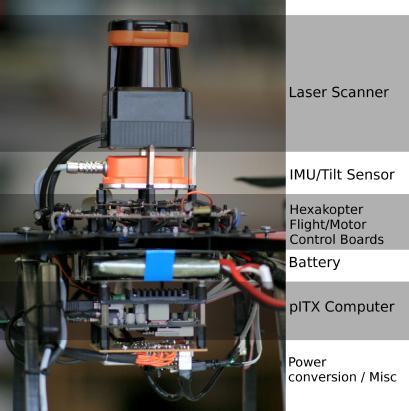
The new XSens IMU and Hokuyo laser scanner arrived about two months ago. Since then I have been working on how to process the data so that the hexacopter can both work out where it is in a room in real-time and then afterwards build up a 3D model of where it flew.
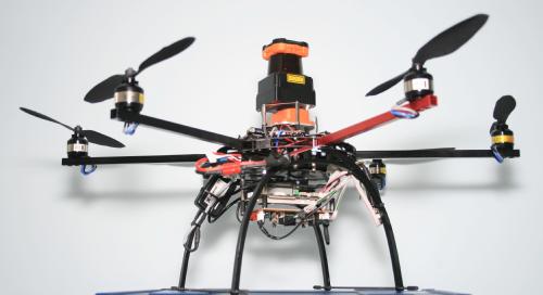
The following pictures show the new sensors layout on the hexacopter
In the past two weeks I have had significant progress with regards to mapping. The helicopter can presently generate a 3d pointcloud map as it flies around in an unknown environment. The images below shows a few maps that the robot generated during testing last week.
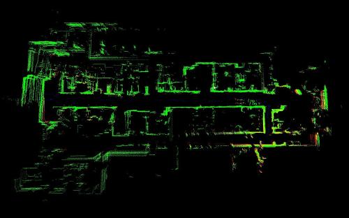
A top-down view of the IMC workshop
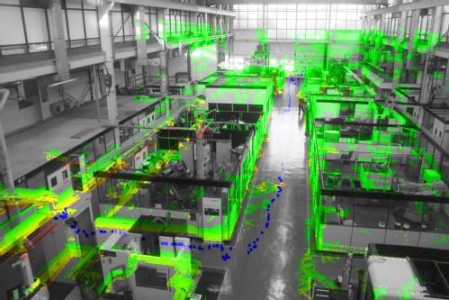
The same scan but from a different perspective and overlaid onto a photo so you can better understand the data (blue dots show the path of the helicopter).
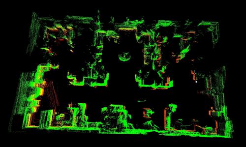
This is a model of our office.
I am hoping to upload an animation of these maps being generated in the next few days.
With mapping now working reliably I have been focusing my efforts on enabling the robot to hover and fly itself. I am very close with cracking the hover, at the time of writing it has managed a 25 second hover in a confined area (+-2metres). I will be recording/uploading a video of this later in the week for you all to see.
Project Update
I will be updating the website shortly to reflect the progress that has been made in the last few months.
In short, the helicopter can now automatically maintain a set height above the ground using the onboard ultrasound sensor. A video showing one of the early tests can be viewed here
Currently, I am investigating how to use the onboard laser scanner to enable the robot to accuratly maintain the helicopters position as well. More information about this will be available soon.


