
Mapping the mappers - undoubtedly my best and most creative academic year
Mapping the mappers – undoubtedly my best and most creative academic year
The final stage of a CIM postgraduate degree is the dissertation research project. This piece of independent research is an opportunity for students to bring together the skills, knowledge and methods they have developed in the first two terms of taught modules. CIM students can follow the theme of their postgraduate degree in their optional modules, or branch out, sculpting their own degree in relation to their interests and goals.
Maria Petrescu investigated collaborative mapping within Coventry’s OpenStreetMap community for her dissertation research. Maria studied the Big Data and Digital Futures MSc with the Centre for Interdisciplinary Methodologies (CIM) and the Warwick Q-Step centre. In addition to her core modules, Maria chose optional modules such as IM919 Urban Data, Theory and Methodology and IM921 Visualisation which are taken by students in the MSc in Urban Analytics and Visualisation, as well as auditing IM923 User Interface Cultures, with the MA in Digital Media and Culture. Maria also took advantage of ongoing research projects in CIM, related to Humanitarian Mapping, and helped establish the “Resilience Mapping” student society, in which students create digital maps of areas in need of humanitarian assistance.
We spoke to Maria about how her time at CIM allowed her to develop an innovative interdisciplinary research approach.
CIM: How did you get interested in ‘Open Street Map’ and get involved with social mapping activities?
Maria: One of my friends, who was here as an exchange student in CIM, told me about the (very) recent start of the Resilience Mapping Society at our university, only the second youth mappers chapter at that time in the UK. So I went to my first ‘mapathon’ where we contributed to a task meant to facilitate the outreach network for Non-Governmental Orgnaisations (such as the Mugumu Safe House) working to alleviate Gender Based Violence in eastern Tanzania.
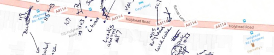
After that first mapathon, I spent a few days trying to get a hang of the mapping interface, squinting at my screen, trying to distinguish between trees and huts on satellite imagery, and telling other friends about OSM, Missing Maps and HOT-OSM (Humanitarian OpenStreetMap Team). Although I didn’t attend as many events as I would like, though my dissertation offered an opportunity to explore this interest. It was also an opportunity to expand my interest in remote, collaborative mapping towards the process of ‘on-the-ground’ mapping, where space is translated into online data.
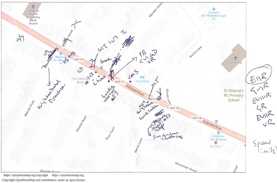
OpenStreetMap ground survey notes
CIM: Your dissertation combined quantitative and qualitative methods in a very interesting way. What were the reasons for choosing this mixed-methods approach and how did you arrive at it?
Maria: Choosing the approach was definitely the most complicated part of my dissertation. My supervisor advised me to test as many methods as possible and move on to the next one if the current one didn’t prove fruitful after 1-2 days. So I went into a ‘method frenzy’! I remember having days when I would just sit down, try to come up with a “new” method and think about how it fitted with my research questions. In the end, as I was reading more about previous research projects on similar topics, I finally managed to see a pattern.
Most research had focused on either discovering spatial and/or temporal trends based on large datasets downloaded from OpenStreetMap, or collecting and classifying motivations for participation in the OSM project (or other collaborative projects, including Wikipedia) through semi-structured interviews or surveys. Ethnographic vignettes of the mapping process were also rare, and their conclusions and ideas were not presented next to any sort of quantitative insights.
At that moment, I remembered this really interesting assignment we had for the IM919 Urban Data module, where we worked in teams on a “data ethnography” of a (local) urban dataset. We got to look at existing online data, visit the real-life places which were considered sources of our data, talk to key actors involved in processing the data and to reflect upon the potential asymmetries between our online and offline experiences in the final dataset. My supervisor had mentioned that I could “go and map” with some local mappers, and I also received really helpful feedback at CIM’s postgraduate conference. All of which led me to think I could look for key moments in the “on-the-ground” mapping process and the attitudes they enable.
I realised that only looking at the mappers’ motivations and the mapping process, or analysing OSM platform data was not going to be enough, so I tried combining them.
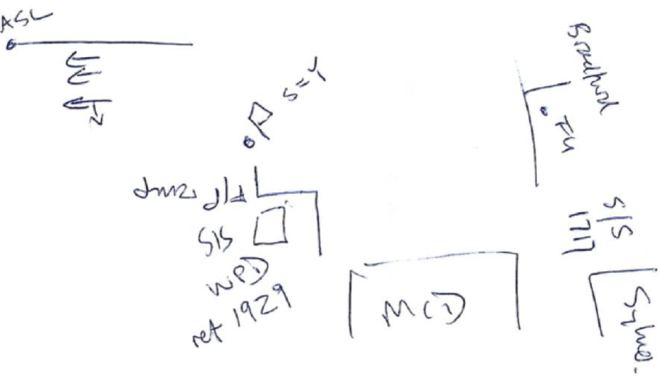
Sketch of elements in and around a substation
CIM: You used the R programming language to process, analyse and visualise your data, had you learnt much programming before studying at CIM? How did the research base on code help inform your ethnographic research?
Maria: I started to learn programming when I was 11, and by the time I applied for undergraduate degrees in the UK I had done 4 years of experience in Pascal, followed by 4 years of C++. My Bachelor’s degree was a Flexible Combined Honours programme, where I majored in Computer Science, alongside International Relations and Modern Languages departments. This experience helped me structure my thinking, making it easier to adapt predefined functions and to write my own functions in R.
Most of my use of R in the dissertation was focused on descriptive statistics and data visualisation (identifying spatial and temporal trends in the OpenStreetMap dataset), which helped me prepare for the ground survey that the Birmingham-based society ‘Mappa Mercia’ were so kind to invite me to. For example, I was able to identify the most prolific contributors taking into account not just the amount of content they’ve added to OpenStreetMap or edited, but also in which areas and how often. I was also able to identify potential decision-making moments in the mapping process and ask about them.
Overall, the R-based research helped me identify patterns and the ethnographic research helped me understand and explain those patterns, as well as the mappers’ attitudes and motivations.
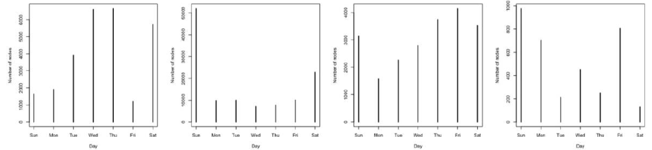
Temporal contributions for selected "dedicated mappers" in the Coventry area
CIM: In the acknowledgments for your dissertation you say that this was “undoubtedly my best and most creative academic year”. Could you tell us more about your experience?
Maria: I was never able to identify a singular background discipline for myself and, until arriving at CIM, I was really worried about that. I was reading job descriptions, looking at course structures for some other postgraduate programmes and I realised I would not be happy committing to one discipline. Fast forward to my first weeks of studies at CIM, I became aware of the creative potential this attitude holds.
I loved seeing how people from such different academic backgrounds were able to work together and truly value insights coming from other disciplines. The ongoing interdisciplinary conversation was always present, from course materials and optional workshops, to trips, conferences and guest speakers. This encouraged me (and I think many of my course mates would agree) to ask questions I’ve never even considered before, to discover new major research interests and to test the limits of my creativity.
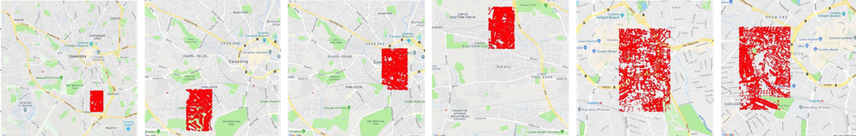
Maria found that the most mapped areas were actually outside the city centre
CIM: Now that you have finished your Masters course, what do you hope to do next?
Maria: A little more than a year ago, I would have been sure that this year would be my last one in a university, not because I didn’t like the thought of going into further study, but because I had not considered it. Since then, however, I’ve realised there are so many things I would like to understand better and so I am hoping I will manage to continue my studies. I have also been applying for jobs and having interviews, trying to see what I can do before my next (potential) step in academia.
CIM: Thank you Maria. We look forward to seeing you at graduations and good luck with your next steps.
For more information on our postgraduate degrees, including the funding available, can be found on our study pages.