WMG Insights
Investigating LiDAR Sensors: Are they prone to interference?
Jonathan Robinson, Project Engineer, Intelligent Vehicles, WMG and Prof Valentina Donzella, Sensor Lead of the Intelligent Vehicles Research Group
Understanding LiDAR Sensor Operation
To enable autonomous vehicles to navigate safely, they need specialised sensors to perceive their surroundings. This section introduces Light Detection and Ranging (LiDAR) sensors, explaining the fundamental principles behind their operation.
To safely and successfully navigate the world around them, humans use their eyes to see, their skin and nervous system to feel, their ears to hear and in some instances, their nose to smell and tongue to taste. These are in effect built in sensors. A vehicle, however, does not have natural sensors it can call upon. Traditionally a vehicle has always relied upon humans, and their natural sensors, to operate its motion. Hence, if we wish to move to a world in which vehicles can drive themselves, we will need to equip vehicles with their own sensing systems.

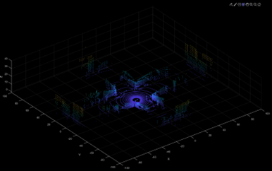
Figure 1: Left) Ouster LiDAR, mechanically rotating LiDAR sensor. Right) Example point cloud from a crossroads junction.
The Role of LiDAR Sensors
Light Detection and Ranging or LiDAR sensors, example shown in figure 1, are one of the sensors expected to be equipped on future vehicles to help them drive themselves in certain situations. The principle of how they work is relatively simple. Imagine a laser beam shooting from the sensor and rebounding off an object and returning to the sensor. Now imagine lots of these laser beams stacked on top of one another. Now imagine they are spinning around 10 or 20 times a second and firing each beam 100s or even 1000s of times per rotation. Got that? Now imagine they are invisible. This is the basic principle of how a mechanically rotating LiDAR works. They are other types of LiDAR but we won’t go into this here.
LiDAR sensors are a range finding sensor. This means they are used to find the distance between the sensors and objects. There are a few ways in which this distance is measured but the simplest is Time-Of-Flight. This works using the well known physics equation . Whilst each beam is invisible to our eyes it is still “light” in the fact that it is an electromagnetic wave, in the infrared part of the spectrum, that travels at the speed of light. Hence, all that is needed is the time it takes for the beam to return and we have the distance travelled to and from the object, which is twice the distance to the object. Combine all these distance measurements from each beam and we have thousands of distance points for every rotation which form a “point cloud”. This will look like a point based map of the surroundings and can be used by a vehicle to understand its environment.


Figure 2: Examples of scenarios where LiDAR interference could be an issue.
Potential Challenges with Multiple LiDAR Sensors
However, if there are lots of vehicles on the road that are capable of driving themselves, many of them could be equipped with a LiDAR sensor or more. If there are lots of these LiDAR sensors operating close to one another, such as on a congested highway, there is the possibility that light from one sensor may interact with the receivers on another sensor. If this was to affect the operation of the other LiDAR, this would be called interference. Do LiDAR sensors interfere with each other? The short answer is, we do not know for sure. The answer to that question may even vary dependent on the type of LiDAR or the manufacturer of the LiDAR. It is an important question to answer though. An example of a situation where interference could be problem is at junctions. If a vehicle is trying to cross traffic lanes, it needs its map of its surroundings to be accurate. If a LiDAR from another vehicle is causing that vehicle to appear 30m closer or further away than it actually is, this could cause the vehicle to either cross the junction unsafely or for it not to cross the junction at all.
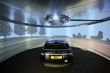
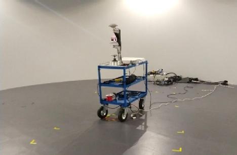
Figure 3: Left) 3xD simulator at WMG acting as a simulator with vehicle inside. Right) 3xD simulator at WMG with a LiDAR on a trolley inside.
Investigating LiDAR Interference at WMG
At WMG we are investigating whether LiDAR sensors interfere with each other to avoid these potential problems. To do this, we use our 3xD simulator, shown in figure 3, as this is a clean environment that has 360° walls used to reflect light from projectors. While the reflective properties may change for infrared light, the reflection should still be consistent in all directions. This means that we can take measurements (and hence produce point clouds) with two or more LiDARs in the environment, comparing the results between when the offending LiDAR is on and off. This will help determine the presence and magnitude of any effect that LiDAR sensors have on each other.
If you are interested in learning more about WMG’s research into autonomous safety, please contact wmgbusiness@warwick.ac.uk.