
An A-Z of Roman Coventry: A-B

A46 Roman features adjacent to the A46 near Piles Coppice and the Bogs - Possible Roman Farmstead
[Ordnance Survey Grid Reference: SP 3850 7721]
Three archaeological features, all of which were of probable Romano-British date, were revealed here in 2002. The features consisted of a linear gully, a small pit and another possible linear feature. Two of these features contained sherds of Romano-British pottery. The topsoil also contained sherds of Romano-British pottery, which is probably the artefact scatter recorded previously during the construction of the A46 Coventry bypass road.
The evidence perhaps points to a Roman Farmstead lying in this area.
Source: Birmingham Archaeology, 2002, Coventry Water Main Rehabilitation 2002-3: Arch
Allesley - Roman pottery recovered at Alton Hall Farm
[Ordnance Survey Grid Reference: SP 2967 8261]
A sherd of Roman pottery was recovered during a field walking survey at Alton Hall Farm undertaken in March 2009
Source: Coventry City Council, 2009, Coventry Historic Environment Project - Field Walking Survey Card, CHEp 09, Allesley, Field no 91 (TEXT). SCT1897.
Allesley – Romano-British coin
[Ordnance Survey Grid Reference: SP 3000 8100]
A coin type known as an Antoninianus (thought to be worth 2 denarii) of the Roman Emperor Claudius Gothicus (ruled AD 268-70) was found in Allesley.
Source: Coventry City Council, 1991, Cov: Enquiries to Museum, 34; 89 (--ARTICLE). SCT690.
Allesley – Hollyfast Farm (NW Coventry) – possible Roman bricks
Ceramic building material (bricks) possibly of Roman date was recovered at Hollyfast Farm during a field walking survey undertaken between October and November 2009.
Source:?
Allesley - Roman pottery recovered at Pickford Grange Farm – Roman pottery
Roman pottery was recovered at Pickford Grange Farm during field walking surveys undertaken in April 2009 and in more detailed surveys undertaken in September and October 2009.
Source:?
Allesley/Ashbrook - Possible Roman Villa north of Ashbrook, Upper Eastern Green
A fragment of Roman tile was found to the south of Pickford Brook, Allesley, in the 1980s or 1990s and in 2009 Roman tesserae (used in mosaics), other Roman building material, mortaria (type of kitchenware bowls) and Roman grey ware (the most commonly found Roman pottery) were revealed during field walking exercises, suggesting that this is the site of a Roman building, possibly a villa.
Source:?
Alvis Retail Park - Roman coins SW of Alvis Retail Park (Holyhead Rd NE Coventry)
[Ordnance Survey Grid Reference: SP 3203 7931]
In 1988, unidentified Roman coins were found in allotments to the southwest of the Alvis Retail Park. The exact location of these finds is unknown.
Follis of Diocletian c300AD?? - Found in an area where other unidentified Roman coins were found in nearby allotments…
Source: Stokes M, 1988, Coventry, 114 Holyhead Rd, 31; 45 (--ARTICLE). SCT52.
Bablake – Babbu Lacu
Modern day Bablake is thought to be named after the ancient Babbu Lacu or Babba/Bubba's Lake or Stream. An AngloSaxon name, perhaps this water feature was named after the same Babba/Bubba after whom Bubbenhall (Bubba’s Hill?) was named.
The exact extent of the old lake is not known. According to some, it stretched from St John’s Church to Swanswell, or Mill Lane to Cox Street, or between Barr’s Hill and Broadgate Hill. It was fed by Radford Brook and the Sherbourne, and the names Babealke, Babilake, and Babylake are all attested in 1336, and Babbelake in 1344. Occupying a prominent site in what is now the city centre, its narrowest point is thought to have been from modern day Bishop Street to the Burges, about 200 yards across.
Roman artefacts have been found either side of this apparent crossing point, with statues of the Roman god of war, Mars, found on either side of the crossing. (Swanswell was Swineswell – created by Boar. XX?)
While modern Bablake School lies away from the site of the original lake, Old Bablake School lies much closer to where the old lake would have been.
Baginton, Lunt Roman Fort
For a detailed account of Lunt Roman Fort, its creation, life, design and archaeology, follow this link.
Baginton - Roman occupation East of the Lunt Roman Fort, Warwickshire
A ditch, two cremation burials and several pits, all thought to be of Roman date were found in several trenches excavated in this area in 2012.
Evidence of Roman activity was seen in a number of the excavated trenches, unsurprising given the proximity to Lunt Roman Fort. Roman remains included two cremations, a small pit and three possible ditches which were probably boundary features. The adult cremation in Trench 180 was buried in an urn that had been placed into a pit and then subsequently backfilled. The archaeology suggests two different actions - the first being the burial of the urn containing cremated human remains that had been deliberately collected from the pyre and the second the deposit of the debris collected from the pyre, including fuel waste, remaining fragments of human bone and remnants of the offering, or offerings made at the time of crematio
The second cremation in Trench 181, which lay 40m to the NE, was not associated with any finds and was probably buried in an organic container or directly into the ground. This implies that there were two subtly different practices occurring. The cremations may be part of a small enclosed area with others present in the vicinity.
The later Anglo-Saxon cemetery could have been located in reference to the Roman activity, indicating an awareness of it or the locations of burials could have been determined by proximity to a local road.
The small pit in Trench 155, which contained pottery of late Iron Age (see section on Prehistory) to early Roman date may be an isolated feature or other similar features may exist in the area. A small cluster of three small pits were also of probable Roman date but the dating material was extremely sparse.
Source: Oxford Archaeology South, 2012, Coventry Gateway Zones A and B: Archaeological Evaluation Report, p.25 (--EVALUATION REPORT). SCT24.
https://news.coventrysociety.org.uk/2020/02/06/digging-up-the-past-in-baginton/
https://www.bbc.co.uk/news/uk-england-coventry-warwickshire-50809706
https://bwas-online.co.uk/excavations-adjacent-lunt-roman-fort-baginton/
Baginton - Site of Roman Settlement to East of Oak Farm
[Ordnance Survey Grid Reference SP 34 74]
Part excavation of a Roman settlement uncovered various features and finds. These included wells and/or pits containing Roman pottery, occupational and building debris, coins and a brooch. The site is located 200m southeast of the church at Baginton.
Baginton - Excavation of Roman Settlement to North of Home Farm
[Ordnance Survey Grid Reference SP 34 74]
Excavation of a Roman settlement uncovered wells pits and a ditch, together with brooches and a quantity of pottery including Samian ware, all probably of Flavian date. The site is north and northeast of the church at Baginton.
Barr’s Hill
Tradition has it that Agricola, the Roman Governor of Britain AD 77-85) built a marching camp on Barr’s Hill and called the settlement after water goddess Coventina. This Coventina is known from Yorkshire (see Coventina in the A-Z). But where does this 'tradition' come from? I am having trouble finding the source of this supposed tradition.
Coins from the time of the Roman Emperor Tiberius (who ruled AD 14-37) have been found on Barr’s Hill, so these will have been carried by a later Roman some time after AD 43. Could Barr's Hill have been a military camp? Without archaeological evidence and the source for the Agricola rumour, this remains very much unsubstantiated.
No source for this local tradition.
Pottery and coins on Barr’s Hill in C19?
Bishop Street – Pillars, causeway, quern, sandals, shrine, spoon, and medallion
In the very centre of Coventry, the area around Bishop Street has seen a cluster of possible Roman finds, many of which were reported in previous centuries and whose true Roman origin is difficult to substantiate. But this cluster gives a real tantalising picture of a possible hive of activity around the area of the old Babbu Lacu.
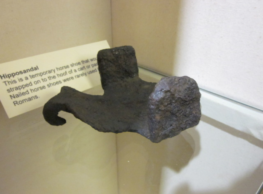
Pillars: It has been suggested that a Roman Road (see 'Roman Road' under R in the A-Z) may have entered city via Bishop’s Street going down to edge of Babbu Lacu where 14th century AD charters state that massive ancient pillars stood, and where Shelton (John Bailey Shelton - 19 March 1875 – 29 November 1958 - a British archaeologist who worked in Coventry and was a pioneer of rescue archaeology) reported finding a quern, hipposandals, and evidence of a wooden causeway across the water.
By site of pillars ‘of great strength and size’ – one survived into C19 and was of Roman design??? –
1868 – “Under the Free Grammar School and round about its precincts are occasionally to be found masses of foundation stones and pillars of great strength and size” Or is this 1848 with construction of Hales St? The Hospital of St John was founded in 1155 by Laurence, Prior of Coventry. The chapel is the last surviving remnant of the complex, which once extended from Bishop Street on the west to Swanswell Pool, to the east. Archaeological remains suggest that there was an earlier chapel on the site, likely to date from the point of the hospital’s foundation; this is thought to have been replaced by the present building in the 1340s.
Is this the Old Grammar School? Right at end of Bishop’s Street. A sanctuary was founded on the site around 1155 by Laurence, Prior of Coventry. It was known as the Hospital of St John and provided help and shelter to the poor and sick.
Alabaster warrior with laurel crown? – ‘considerably below surface of Bishop Street and near the Free School there’. 1796. Is this the head in the museum?
Quern???
Horse shoes??? Shelton found horseshoes – hipposandals and causeway
https://www.vindolanda.com/news/hipposandals-on-display
- vindolanda
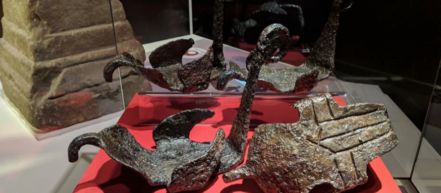
Various theories have been put forward regarding what hipposandals were used for. Here are the most popular ones
From Lunt
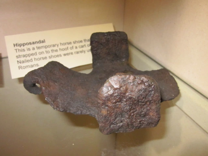
1) Temporary horseshoes
The most common theory is that these iron objects were a type of horseshoe. They were not nailed to the horses’ hooves like modern horseshoes but rather worn tied with cords made of organic materials. Hipposandals could be fitted by anyone who owned a horse, with little need for specialist farrier knowledge. They could be carried easily, and just as easily be replaced. They would have been very useful when on remote postings or expeditions. However, all horses’ gaits (but mostly trot, canter and gallop) involve the 4 legs collecting close together under the body of the animal, either 2 by 2 on the ground or all 4 in the air. Any horse may have damaged its own legs if manoeuvred at pace while wearing such heavy sandals. In fact, some researchers support the theory that hipposandals are not horseshoes at all: according to them they could only have been used on slower pack animals such as oxen, mules and donkeys.
2) Hobbles (leg restraints)
The hipposandals could have been fitted on two or four hooves. The front hooves would have been fitted with hipposandals equipped with front-facing loops, that would have then been tied together. This would have only allowed the horse to move a few inches at a time and would have stopped pasturing horses from straying.
3) Medicinal, offensive or traction horseshoes
Hipposandals could have been used as a medicinal shoe, which could carry a salve packed in or around the iron and therefore kept firmly on the hoof and frog (the soft part of a horse hoof located on the underneath of the foot). They could have also been used for offensive purposes, for example, riding into battle wearing these would have avoided painful caltrops, which could have made a horse lame, or for better traction on ice and mud. The Vindolanda sandals are scored, not studded, but may have worked to guarantee a firm grip in wintery conditions, when pace was forcibly slow.
But what of Cox Street as Roman Road?
Medallion: Old Blue Coat School - 1856 Naked woman medallion at Old Blue Coat School among ruins of old cathedral – naked woman holding flower, and pouring from jug on reverse.
Priory Site - Water Goddess medal Priory site? An ancient coin-like object was discovered near the Priory Mill in New Buildings in the last century. This had on one side, a woman pouring water from a jug, and on the other a naked woman with a flower at her feet. It is possible that this has some connection with the legend.
Located within the Cathedral Quarter of the city centre, this chateau-style Blue Coat School is believed to have been founded in 1714 as a charity school for girls who spent their last two years being trained in the rigours of domestic service. The present building is built over the ruins of the Cathedral and Priory of St Mary's. It dates from the 1850's and was restored in 2000. Address: 5a Priory Row, Coventry City Centre, CV1 5EX
Spoon: Patera kept in St Mary’s Hall and called our Lady’s spoon. St Mary’s Guildhall?
For hundreds of years the ruins of Coventry's first Cathedral lay hidden beneath the City Centre. The 'Phoenix Initiative', Coventry's Millennium project, gave archaeologists the opportunity to excavate this important site. Over several years the remains of many of the medieval buildings were uncovered. Some of the ruins have been reburied for their protection, but gardens have been designed over them to reflect the archaeology below. The garden built over the site of the cloister includes the Visitor Centre. The Priory Undercrofts offer a fascinating glimpse into the best preserved remains of Coventry's original Benedictine monastery, dissolved by Henry VIII
https://www.historiccoventry.co.uk/engravings/content.php?pg=mill-dam
Broadgate - paddle and mosaic and Statue Mars 1792
Is this the south end of the lake crossing? With pillars of Bishop’s Street the north.
Letter to Leamington Spa Courier 8th July 1893 J A Sparvel-Bayley
“…In 1792 near Broad Gate at nearly 6ft depth, fine tessellated pavement (mosaic?) with middle brass coin of Nero. Graceful design of scroll and squares with labyrinth centre destroyed. Contained possibly figure of a deity? Same time ten inch figure in old part of town…one of deities?”
Mosaic and coin: Gentleman’s Magazine 1793 – Broadgate in Coventry, 5 or 6 ft of excavations unearthed a pavement and coin of Nero. As above.
Coin not only one found at Broad Gate. William Fretton C19 wrote ‘I have several Roman coins found in this locality’
McGrory has coin of Domitian found in rebuilding Broadgate Domitian.
Mars: At same time while digging foundations of house in old part of town, 10 inch statuette. Right hand resting on shield, head bound with filet resembling wheat – a deity? But not give precise location. Shield and wheat sheaf. Celtic god with baguette and wheel from Campbell?
Paddle: Finds made by Shelton (when) - a possible Roman coracle paddle and a Bronze Age socketed axehead.
Ordnance Survey Grid Reference: SP 3335 7908 (end of Bishop Street)
1> Findspot of a ?Roman coracle paddle; a socketed bronze axe at 12ft deep;.
<1> J. B. Shelton, 1949, The Story of Twenty-Two Years Excavations in Coventry, p.31 (-MANUSCRIPT). SCT1614.
Sources and Further Reading
<1> SCT1614 - -MANUSCRIPT: J. B. Shelton. 1949. The Story of Twenty-Two Years Excavations in Coventry. Shelton, J.. A4 duplex. 41. p.31.
Water-pipes made of wood: 1945, Municipal exhibition displayed Roman? Wooden water pipes from Broadgate