
Episense IPCC Satellite Meeting
Episense Satellite Meeting
With new developments in sensor technologies and data processing, remote sensing is making exciting advances in the accurate detection and monitoring of crop pests and disease.
From hand help sensors in the field to multispectral and hyperspectral sensors on drones and satellites, our ability to detect and monitor crop health is rapidly improving, from leaves to landscapes. This offers the possibility to revolutionise our understanding of plant pathogen interactions as well as arming farmers and plant health bodies with better tools to detect, monitor and manage disease outbreaks at scale.
The Warwick Crop Centre co-organised a recent satellite event on remote sensing in plant disease epidemiology at the International Congress for Plant Pathology (ICPP 2023) in Lyon France 18-25th August 2023.
The “Episense” event focused on linking research communities working in remote sensing and plant disease epidemiology to discuss the latest advances and how epidemiology can inform new remote sensing data and vice versa.
Episense was co-organised by the University of Cambridge, University of Reading, INRAE and the University of Lorraine and was attended by over 60 researchers from 21 countries. Contributions were led by keynote talks from Prof Pablo Zarco-Tejada (University of Melbourne), Prof Uwe Rascher (Bonn University) and Dr Katie Gold (Cornell University).
The researchers discussed a wide range of opportunities presented by remote sensing including applications in disease surveillance, monitoring the breakdown of resistant crop varieties, targeted application of control measures, and improved understanding of landscape epidemiology.
While the future use of remote sensing in crop protection looks bright, development of the approaches relies on the availability of data from traditional surveys of pest and diseases on the ground to train the approaches.
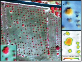
Recent work involving members of the Warwick Crop Centre has shown how the combination of epidemiological spread models and remote sensing can produce accurate maps of plant disease distribution. The above example shows an overview of an almond orchard infected with Xylella fastidiosa. Image: Camino et al., (2021) https://doi.org/10.1016/j.rse.2021.112420Link opens in a new window