
Astronavigation
Space, as has been noted before, is big [1]. In the three-dimensional vastness of deep space, amongst species who may have few common reference points, navigating from point A to point B presents severe challenges. Science fiction has addressed the astronavigation problem in a wide variety of ways.
Hyperspace Navigation
Faster-than-light interstellar travel, as seen in the majority of science fiction, is problematic in a number of ways - in terms of required technology and laws of physics in particular, but also in terms of navigation. Given that any maps based on astronomical observations are subject to light travel delays (i.e. the fact that the image we see reports the system as it was when the light left, rather than as it is "now"), stars used as reference points could potentially have moved or even expired before any ship reaches them. For any science fiction that hypothesises ships passing into and out of some form of other- or hyper-space, even those objects which remain fixed and unchanged in real-space may not be visible while in faster-than-light travel. As a result, one of the most famous astral navigation instructions - “Second star to the right and straight on ‘till morning” (as issued by Peter Pan and Captain Kirk at different times and in different places) - is fraught with difficulties.
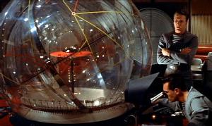 An influential and traditional approach to navigation is seen in the film Forbidden Planet (1956, dir. Wilcox). Here the navigation area within the United Planet star ship C-57D features a large transparent sphere, with the position of the cruiser indicated within a grid of fixed reference points and vectors. Although these remain unexplained, the three-dimensional nature of the charting exercise recognised that two dimensional charts were not suitable for free navigation in space, and likely influenced other fictions which showed three dimensional navigation spaces in the following years, especially those with spherical spaces, or hologrammatic representations.
 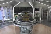 In some cases, the navigator would themselves be inside the sphere, while in others (as shown in the image from Forbidden Planet) navigation would be undertaken as if looking from outside and calculations used to translate into guidance for the ship's helm. An example here can be found in the starship Jupiter Two, which famously became Lost in Space in the television series of the same name (CBS, US, 1965-1968, produced by Irwin Allen). The Jupiter Two had a hemispherical astronavigation console, known as the astrogator, which generally performed well for relative position navigation - but proved useless for finding Earth or Alpha Centauri when the ship lost its absolute reference points.
 The difficulty of establishing the reference points against which to anchor a three (or four) dimensional coordinate grid is one which has exercised a number of writers. “The Repairman” by Harry Harrison (1958) is a short story focussing on an international troubleshooter responsible for maintenance and repair of interstellar hyperspace beacons. As the unnamed narrator character explains, this is a job of enormous significance:
The first ships to enter hyperspace had no place to go—and no way to even tell if they had moved. The beacons solved that problem and opened the entire universe. They are built on planets and generate tremendous amounts of power. This power is turned into radiation that is punched through into hyperspace. Every beacon has a code signal as part of its radiation and represents a measurable point in hyperspace. Triangulation and quadrature of the beacons works for navigation—only it follows its own rules. The rules are complex and variable, but they are still rules that a navigator can follow. For a hyperspace jump, you need at least four beacons for an accurate fix. For long jumps, navigators use as many as seven or eight. So every beacon is important and every one has to keep operating. That is where I and the other trouble-shooters came in.
In this story, a problem arises when an ancient, 2000-year-old beacon malfunctions, and proves to have become a focus of religious worship on the planet where it is located, forcing the investigator to improvise in order to gain access. Interestingly, this beacon is described as being on one of Proxima Centauri’s planets, and perhaps amongst the first beacon Earth built - a potentially-prescient comment given the recent discovery of Proxima Centauri’s family of planets.
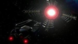 This idea that some form of hyperspace beacons can be established is fundamental to a lot of science fictional navigation. This is the role served, for example, by the Jump Gates in Babylon 5. While some ships are capable of generating their own jump points, they risk becoming permanently lost without the jumpgate network transmitting reference signals. Indeed the episode “A Distant Star” described characters taking an enormous risk in deliberately taking their ship “off the beam” in search of a missing starship, potentially leaving them permanently lost. Here the beam is described as a stream of tachyons (faster-than-light particles) generated by the jumpgates, and the characters find their way home by several small ships making a chain of contact, with only one end of the chain in touch with the beam and the others navigating with respect to one another [2]. However, as was the case for the energy beam in “The Repairman”, figuring out a way to generate jumpgate-like hyperspace beacons - or even establish the existence of any such extra-dimensional space - is still far beyond our technology and physics.
Beacons are also the plot driver of George O Smith’s novel Troubled Star [3]. In this story, a group of workers from an interstellar shipping line on the planet Marandis are tasked with setting up an interstellar beacon in our own Solar System to aid their interplanetary travellers:
“...you cannot even see Marandis from here, even with the finest telescope ever built. Stars lie in the way, huge gas fields and nebular clouds block fast direct passage. To chart our course safely past such stellar menaces, we establish beacons at the ends of certain free passages. For instance, Sol lies at the end of a fifteen hundred light year straightaway from the last beacon we set up. Here at Sol a slight turn in the course is made and there is another straightaway for a thousand light-years toward the Spiral Cluster. We—my friends and I—are charting the course through a rather interesting rift from Marandis to the Spiral Cluster. This rift, along which you lie, has been hidden from us for thousands of years. When it is finished it will cut hours from our travel-time."
"And maybe so. But what is a beacon and how do you establish it?"
"Dusty, when a spacecraft is running at fifteen hundred light-years per hour, a three-day-variable star winks in the sky ahead like a blinker-light." Scyth chopped his left palm rapidly with the edge of his right hand. "Wink-wink-wink it goes. And the pilot puts his spacecraft point-of-drive on the beacon and holds it there until he passes it and aims to the next."
Unfortunately converting our sun to a suitable three-day-variable beacon would require its brightness to change by a factor of a hundred over that time period - alternately baking and freezing Earth and certainly compromising its current habitability!
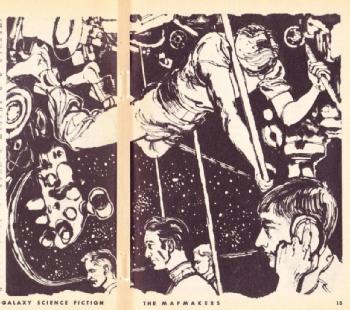 In Troubled Star, the behaviour of variable stars is measurable even when vehicles are travelling faster-than-light, suggesting that they are not travelling through hyperspace as it is sometimes discussed but rather through our own space-time. The potential disconnect between beacons and travel in hyperspace and real space is discussed in Frederick Pohl’s short story “The Map Makers”, which appeared in Galaxy magazine in July 1955 and was adapted for the radio anthology series X-Minus-One. Here a particle of meteoritic dust strikes an exploratory ship, Terra II, throwing it off course and out of hyperspace, and destroying its “Celestial Atlas” - “the only record on board of the incomprehensible Riemannian configurations of hyperspace” - in this case the atlas is not a printed book, or even a computer record, but instead a human with special mathematical gifts, eidetic recall and hypnotic training. Usually this individual would guide them between celestial reference points. Without any reference points, the crew of Terra II risk becoming permanently lost if they re-enter the jarring sensory-chaos of hyperspace without knowing where they are already. Pohl carefully uses the language of complex geometry and physics (including the perfectly genuine concept of Riemannian manifolds) to make his hyperspace appear plausible - and the difficulty of navigating it obvious - but is forced to resort to preternatural abilities to resolve the challenge he describes.
Another use of such enhanced (almost superhuman) abilities can be found in Frank Herbert’s Dune series (starting with Dune, novel, 1965). The narrative in this series focuses on the possession and control of the rare drug Melange or spice, which has a number of effects… including lending humans psionic talents which include the ability to navigate in hyperspace. Like many long-running series, the chronology and canon of the Dune universe is rather convoluted, but supporting media (e.g. The Dune Encyclopedia; McNelly, 1984) suggest that the (in-universe) historical jihad against man-machine interactions took the early navigation computers used by hyperspace starships out of the equation, with only human solutions permitted thereafter. The calculations required for space navigation lie beyond normal human capacities and so require spice-mediated prescience. In Herbert’s books this is the unique prerogative of the enormously powerful Spacing Guild (at least until after events on the planet Arrakis in the books themselves).
Whether navigated by blind reckoning, beacon or by preternatural abilities while in some form of hyperspace, the apparent relative motion and evolution of stars in the Milky Way would require the ships’ real-space reference frame to be constantly updated for interstellar navigation. An episode of the 2003 Battlestar Galactica television series (“Scattered”, TV, 2005) actually pivoted on this point. An incident on the bridge of Battlestar Galactica itself causes a distraction which leads to a navigation error that results in the vessel's separation from the fleet of refugees it guards:
"Every watch we update our emergency jump calculations with new star fixes to compensate for inertial drift, and then we transmit them to the rest of the Fleet. This time ours were updated, but theirs weren't. Gaeta was supposed to transmit them to the rest of the Fleet." Colonel Tigh, Battlestar Galactica, “Scattered”
This kind of fix is hinted at in a lot of science fictions and appears to rely on identifying a number of stars through their emission. Usually this is described as occurring through some kind of spectroscopy (this was the case, for example, in James Follett’s science fiction radio drama Earthsearch where the young protagonists routinely survey stars they pass spectroscopically) in which the distinctive chemical fingerprints of each star are seen as emission and absorption lines, although at our current level of technology, many stars will have sufficiently similar spectra to be indistinguishable. The job of mapping, identifying stars and plotting routes is often relegated to a computer in modern science fiction - as in the case of the Millennium Falcon’s navi-computer and astromech droid R2-D2 in the Star Wars universe (starting with Star Wars, film, 1977).
 In the Star Trek universe (starting with Star Trek, TV, 1966) we generally learn little about how the navigation process is undertaken, although mapping seems to be a routine activity for many ships. Starships are equipped with astrometrics labs and stellar cartography is described as being taught at Starfleet Academy. In the animated series Star Trek: Lower Decks (TV, 2020-) we are also introduced to Cetacean Ops: a flooded region of the USS Ceritos crewed by Beluga whales who serve as astronavigators. As with many aspects of Lower Decks, this is based on an in-joke amongst the Star Trek fan community - in this case a reference to Star Trek: The Next Generation Technical Manual and blueprints books which described the USS Enterprise NCC 1701-D as also having a Cetacean Ops section (and was itself apparently a reference to cetacean navigators in an earlier anime). Even if meant as a joke initially, there is a logical argument for including marine life forms amongst the ship’s navigators. Unlike ground-based animals, or even ground-dependent birds, many marine animals routinely navigate a three-dimensional undersea space which might train their instincts regarding spatial navigation. Navigation also becomes crucial when starships are well beyond the limits of mapped space. Indeed we see the starship Voyager facing a huge navigation problem, and a substantial advance in routing efficiency made when a new billion-star-scale navigation system and a new astrometrics lab is developed (Star Trek: Voyager episode “Year of Hell”, TV, 1997) [4].
More complications are introduced when humans attempt to use the navigation charts created by another species with a different visualisation of space, particularly if these are also old enough to also be affected by stellar apparent motion. This is not often explored in science fiction, although it was addressed by Frederik Pohl in his Gateway series story “Beyond the Gate” (Amazing Stories, Jan 1984). Here Pohl’s explorers make a living in finding and using technology from a long-vanished race called the Heechee. However the maps they find can lead them into difficulty rather than profit:
“The Heechee charting and navigation systems were not easy to decipher. For navigation, the system looks up two points, the start and finish of the trip, it then looks up all intervening obstacles such as dust or gas clouds, perturbing radiation, gravitational fields and so on, and selects points of safe passage around or between them, after which it constructs a spline to fit the points and direct the vessel along it.
Many objects and points on the charts were tagged with attention marks — flickering auras, check marks and so on. We realized early that these were often warnings. The difficulty was that we didn't know which signs were warnings, or what they warned against.”
Real Space Navigation
Coming down in scale from interstellar and superluminal travel to Solar System-constrained real-space travel, navigation remains a problem. The relative positions of the planets are constantly changing, and only provide a single ecliptic reference plane, while the surface of the Sun is also rotating and changing (due to sunspots etc) and so cannot easily be used for orientation. Indeed, the difficulty of such navigation is recognised even in the science fiction comedy series Red Dwarf, in which the officious but incompetent character Rimmer notoriously failed his astronavigation exam no fewer than thirteen times.
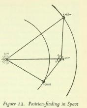 Astronavigation within the solar system was discussed by science fiction writer and science communicator Arthur C. Clarke in a chapter of his 1951 science fact book The Exploration of Space. Clarke suggested (with some accuracy) that the primary method of navigation would be triangulation of the positions of planets, which would have to be combined with known tables of ephemerides (predictions for the location and movements of individual planets at a given time). As he pointed out, while the background stars can tell you the direction you have travelled in, on solar system scales a star map will not change to give you a distance, or allow the calculation of velocity. Triangulation will give you the former (if the location of the planets at a given time are known in advance). For the latter, Clarke suggested the use of doppler shift (the same effect that changes the sound of moving vehicles such as passing trains) measured from ground-based radio beacons. Indeed, this is the technology still used by NASA - current radio and radar doppler tracking technology is accurate to scales of about a kilometre at the distance of Saturn’s orbit.
Of course, radio beacons can only be placed in regions already reached, and are also challenging both in terms of power required for transmission and time delay for more distant interplanetary craft. Clarke also pointed out that the angular diameter of a planet (the fraction of the sky it fills) may also be a useful gauge of distance for space vehicles that are in, or approaching, close orbit, although less so for those at a large distance from the planet being measured.
A relatively early discussion of the difficulty of near-Earth space navigation can be found in the radio science fiction drama Journey Into Space (written by Charles Chilton for BBC radio, 1953). Here Captain Jet Morgan and the crew of the first moon landing intend to be in constant contact with their ground station at Wonga Walla in Australia, who update them with position and velocity. However one of the first problems the crew faces is a loss of communications between Earth and Rocketship Luna.
Lemmy: “The radar’s still working!”
Jet: “Well, that’s something. At least we’ll be able to calculate our height above Earth.”
Mitch: “Yes, but we can’t depend on the radar. Not for the whole trip.”
Jet: “We can depend on it for a few hours yet.”
Mitch: “For height, yes. But what about course?”
Jet: “Well, if necessary, we’ll have to take fixes on the Sun and planets but, well, let’s hope it doesn’t come to that. It’ll take some figuring.”
This potentially poses a serious problem for navigation, and one which grows cumulatively worse the longer contact is lost. The uncertainties and errors in measurement at the point of last contact are small, in the event of a communications failure, but as time goes by, they are compounded by uncertainties in our model of the Solar System’s gravitational potential and could lead to the vessel being significantly off course. Any gravitational force (i.e. distant large object or nearby small one) not accounted for in the model will tug a coasting space vessel in an unlikely direction. Without onboard computers or contact with Earth, the crew of Luna daren’t proceed based on relatively-inaccurate star and planet fixes alone - to the point where Captain Morgan considers abandoning the mission entirely. It’s interesting to note that the writer of Journey Into Space, Charles Chilton, was in contact with the British Interplanetary Society, of which Arthur C. Clarke was a leading light - so perhaps it’s not entirely surprising that their hypothesised methods are so closely aligned.
While the gravitational landscape of the inner solar system is now fairly well known (much better so than it was in the early 1950s), there are still uncertainties - indeed the Pioneer Anomaly (an observation that the Pioneer space probes were travelling on an unexpected course) led to significant speculation on this score for many years, although their acceleration has now been explained through uneven heating of the spacecraft surface. Like the Pioneers and Voyagers, the space probes launched by mankind over the last few decades have been navigated primarily through a combination of dead reckoning and radio/radar doppler positioning, but also routinely checking whether they are with reference to the visible stars. Indeed, as recently made news headlines, even the ancient Voyager II probe is capable of figuring out where Earth lies through star triangulation when needed - although this is a back-up system rather than its primary navigation mechanism. However, particularly in recent years, NASA have also explored another interesting possibility: using pulsars as reference points.
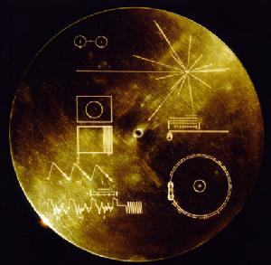 Famously, the Pioneer probes, and later the Voyagers, carried plaques designed to communicate the existence of humanity and some key details to alien intelligences, using mathematical symbols to establish a universal language and primarily designed by scientist, science fiction writer and science communicator Carl Sagan. Amongst the imagery used was a starburst-like design, in which each line connected the location of the Sun (and hence Earth) with an individual pulsar. These are highly-magnetic, spinning neutron stars, whose light pulses at high frequencies, which can be measured to very high precision. Because the frequency is slightly different for each pulsar, each line on the Pioneer probes could be labelled with its pulsation frequency and so uniquely identify the Sun’s location relative to 14 different reference points scattered through the Milky Way.
Effectively, this is similar to the beacon approach mentioned above, but is rather problematic in a range of ways. First and foremost, we now know that the pulsar phenomenon is very directional - the ray of pulsing light effectively shoots out from the star like a laser beam and it is only from very close to Earth’s location that more than a handful of the selected pulsars will be seen to pulse. This is quite unlike the variable star beacon approach that appeared, for example, in Troubled Star - a stellar variable radiates in all directions and so can be seen from any angle… unless an intervening dust or gas cloud modifies its light [5].
Given that pulsars are very precise clocks, their use as navigation reference points could also become confused if the neutron star sources and the observer are in relative motion and not aware of the fact, leading to a doppler shift in one pulsar masquerading as the rest-frame frequency of another. Since all objects in the Milky Way are in relative motion, this is almost inevitable without extensive prior knowledge of the pulsar sky.
On the other hand, while pulsars may not be reliable the beacons Sagan intended over interstellar distances, they may prove to be more useful than initially expected within the Solar System itself. The timing of pulsars can now be measured with sufficient precision for a spacecraft to locate itself within the solar system to the nearest five kilometres, as recently demonstrated by a NASA instrument, NICER, on the International Space Station. Another space probe, New Horizons, has also recently demonstrated its ability to measure parallax (the apparent movement of nearby stars relative to distant ones, equivalent to the way a finger held vertically in front of your nose appears to move against the background when closing each eye in turn) by comparison between its observed location for individual stars and similar measurements taken from Earth at the same time. While these changes are small on Solar System scales, they can be significant from one side of the system to the other, or at larger distances. The difficulty here is both one of measurement precision and of picking the appropriate targets. For near-Earth navigation some of the nearest stars will make small shifts against the more distant stellar background. For interstellar travel, it might be possible to extend the technique with objects such as globular clusters, which lie on the edge of our galaxy, but will move against the extragalactic sky, while for intergalactic travel, entire galaxies or quasars would need to be picked as references.
In practice, interplanetary and interstellar navigation will likely combine a range of measurements - many of them based on the same principles of triangulation, stellar direction finding and parallax which have been used at sea for centuries. Others, like radar and doppler ranging, have been demonstrated over decades, while some, like pulsar location finding and stellar parallax have only been measurable in the last few years. Extending these techniques to hyperspatial travel - if such exists and if we can find a technique for it - might prove trivial… or impossible. In fact, it’s all too likely that the main limitations in space navigation will prove not to be the measurement techniques but rather the capacity of the human brain (trained on the two-dimensional surface of a planet) to comprehend them.
"Astronavigation", Elizabeth Stanway, Cosmic Stories blog, 22nd October 2023.
Notes:
[1] source: Douglas Adams (1978). [Return to the text]
[2] The same trail-of-breadcrumbs life-line approach was used much earlier to locate and rescue a missing pilot in the original Battlestar Galactica episode “The Lost Warrior” (1978), where the location of the mother ship couldn’t be broadcast due to the threat of pursuers. [Return to the text]
[3] This novel is also one of a curious sub-genre of actor-mistaken-for-spacemen stories in SF that I might come back to another time. [Return to the text]
[4] In technical terms, this kind of multi-object triangulation and simultaneous solve for navigation would be what is known as an "np complete" problem and likely need quantum computing since no efficient classical algorithm exists. [Return to the text]
[5] The viewing-angle effect is a problem for many different cosmic landmarks. The Battlestar Galactica episode "Home part II", for example, features a character recognising the Lagoon Nebula in an illustration of Earth’s night sky. But such a nebula would look different from any other angle, suggesting that if the nebula is a known feature, the Galactican colonies, Earth (in two incarnations!) and the nebula must coincidentally all lie on the same straight line… which is a convenient coincidence. [Return to the text]
The views expressed in this blog entry are those of the author and do not necessarily reflect those of the University of Warwick. Images sourced from public websites and used here for commentary and criticism.