Spanish Civil War maps
Examples of maps published during the Spanish Civil War are shown below. They contain a range of geographical, political, economic and military information, and are all taken from archives held at the Modern Records Centre. When the whole document has been digitised and is available online, you can click on the reference number to see the complete item.
The maps are divided into six sections: Europe, Spain (whole), Northern Spain, Southern Spain, Madrid and North Africa.
Europe
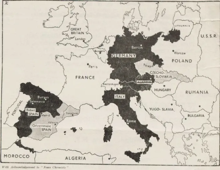
'What victory for Franco in Spain would mean', 1938
This map was included in a leaflet for a proposed National Emergency Conference on Spain, to be held on 23 April 1938. Territory under the control of "fascist" governments is highlighted in black, to emphasise what the author argues is an encirclement of France by fascist powers, and a threat to British trade routes in the Mediterranean.
From the archives of the Trades Union Congress, document reference: 292/946/18b/53.
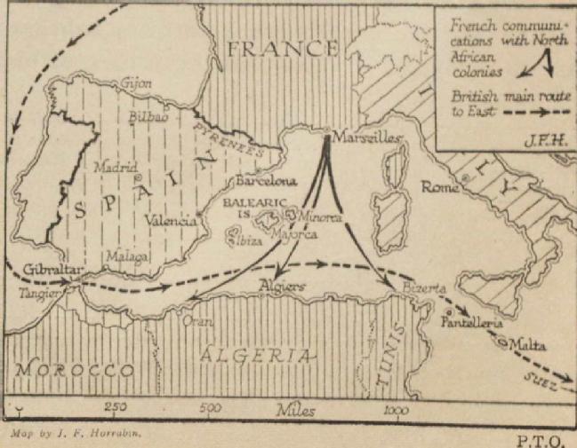
'There is grave danger...', 1938
This map was included in a leaflet issued by the Spanish Emergency Committee. It illustrates how Spain is in a key position to affect British trade routes to the east (including India) and the route of French shipping to colonies in North Africa.
From the archive of the Trades Union Congress, document reference: 292/946/18b/78Link opens in a new window.
Spain (whole)
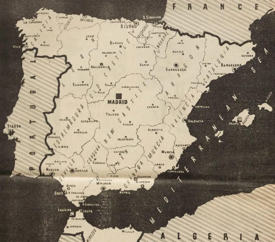
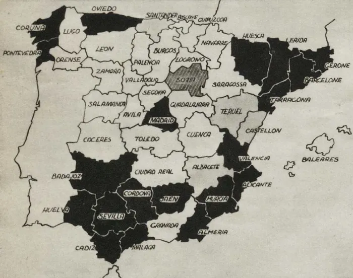
Spanish Regions, 1936
Map showing the regional divisions in Spain. This was included in the Communist magazine 'To-morrow', published in December 1936.
From the archive of Henry Sara, document reference: 15/3/8/239.
Spain: Results of the 1936 parliamentary election
Map taken from a 1937 magazine 'No Pasaran', produced by the Belgian Labour Party. It identifies which regions had cast most votes for the left and right-wing political parties in the February 1936 parliamentary election. Areas coloured black had a left majority, white areas had a right majority, light grey areas were closely divided between left and right, and the dark grey area had voted for parties of the centre.
From the archives of Paul Tofahrn, document reference: MSS.238/PUB/4/4Link opens in a new window.
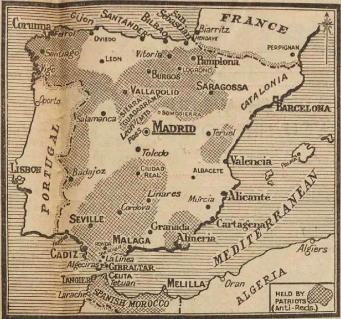
Spain, 8 August 1936
Map taken from The Daily Mail, 8 August 1936, showing the territory thought to be in the hands of the rebels (referred to by the Mail as "Patriots (Anti-Reds)"). It accompanied articles about "the Red's reign of terror" in government Spain.
From the archives of Henry Sara, document reference: 15/3/8/57.
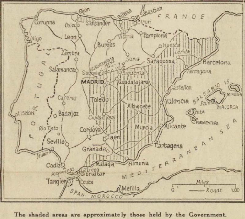
Spain, 18 August 1936
Map taken from the Manchester Guardian, 18 August 1936, showing the areas held by the opposing forces a month after the military rebellion. It illustrated an article headlined 'Fight for San Sebastian'.
From the archives of Henry Sara, document reference: 15/3/8/93.
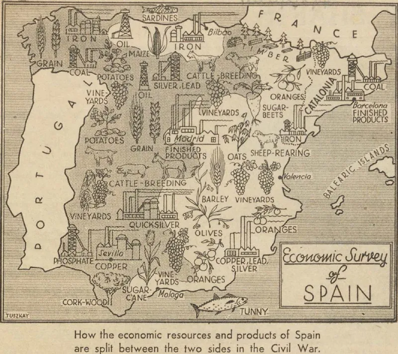
'Economic survey of Spain', undated [1937?]
Map showing the distribution of industry and agriculture across Spain. Territory under Nationalist control is shaded grey, territory under Republican control is white. This cutting is from an unidentified newspaper.
From the archives of Henry Sara, document reference: 15/3/8/4.
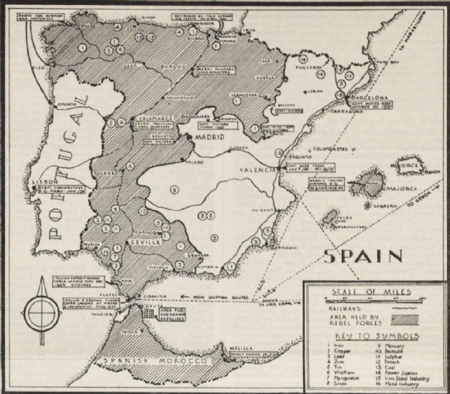
Spain: mineral wealth, 1938
Map showing the location of key mineral deposits and related industry. Territory under Nationalist control is shaded grey, territory under Republican control is white. This was included in the pro-Republican journal 'The War in Spain: A Weekly Summary', 12 February 1938.
From the archives of Henry Sara, document reference: 15/3/8/256/3Link opens in a new window.
Northern Spain
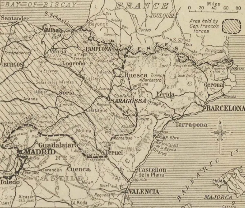
North East Spain, 1938
This map was published in The Times in March 1938. It accompanies an article headlined 'Swift Franco Advance: The Invasion of Catalonia' and, as well as the main towns in the region, identifies which territory was held by General Franco's forces.
From the archives of Henry Sara, document reference: 15/3/8/6.
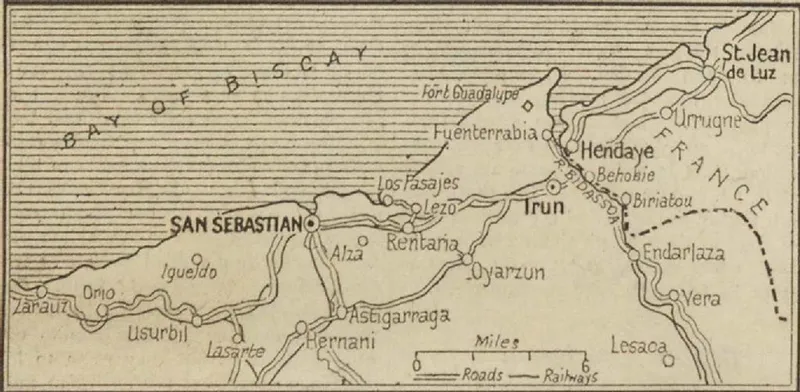
North coast: San Sebastian and Irun, 1936
This map was published in the Manchester Guardian on 28 August 1936, and illustrates an article reporting on the Nationalist offensive in northern Spain commanded by General Mola (headlined 'Rebels fail again to capture Irun').
From the archives of Henry Sara, document reference: 15/3/8/116.
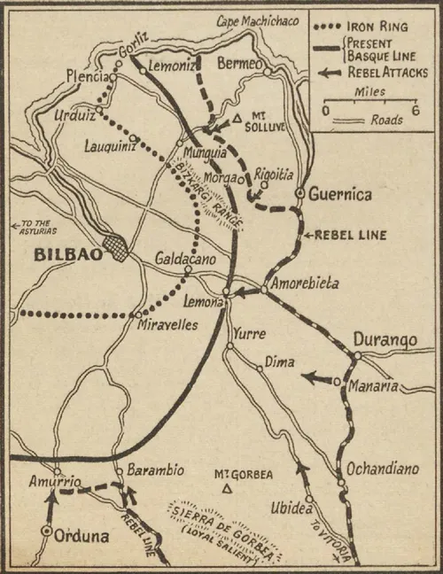
Bilbao area, Basque Country, 1937
This map shows the area to the east of Bilbao, and was published in The Manchester Guardian on 1 June 1937. It includes the towns of Guernica and Durango, both of which had suffered devasting aerial bombardment, and shows the positions of the opposing forces.
From the archives of Henry Sara, document reference: 15/3/8/185.
Southern Spain
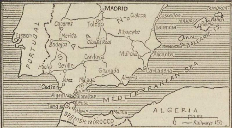
Southern Spain and North Africa, 1936
Map showing the main towns in Southern Spain and Spanish Morocco. This was included in the Manchester Guardian on 11 August 1936, and illustrated an article headlined 'New threat to Madrid... Rebels moving on Badajoz'.
From the archives of Henry Sara, document reference: 15/3/8/63.
Madrid
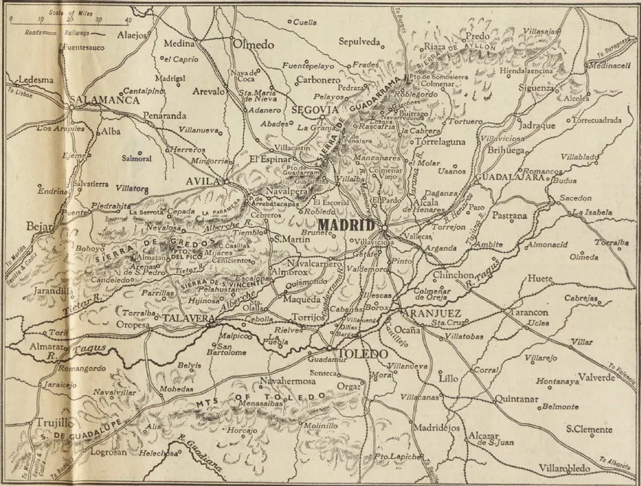
"Heart of Spain", 1936
Map of the area immediately surrounding Madrid, published in The Observer on 4 October 1936. It accompanies an article on 'Gen. Franco's plans for Spain', written at the time of a Nationalist offensive towards Madrid.
From the archives of Henry Sara, document reference: 15/3/8/152.
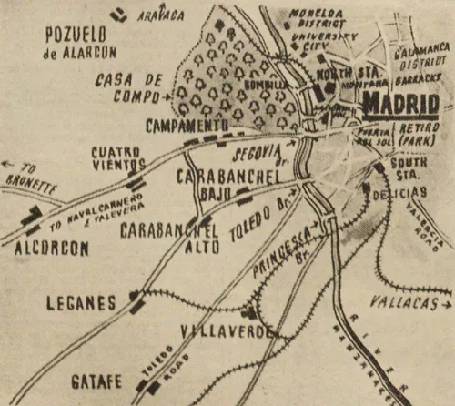
Madrid, 1936
This map shows the towns and villages in the immediate environs of Madrid, and was published in the Communist magazine 'To-morrow' in December 1936. It focuses particularly on the west side of the city, as the Nationalist forces were attacking from this direction.
From the archive of Henry Sara, document reference: 15/3/8/239.
Madrid, 1936
City plan of Madrid, published in the French magazine 'Guerre Civile en Espagne, Septembre-decembre 1936'. It highlights significant districts and buildings, including the Cité Universitaire, an area where major fighting had taken place.
From the archives of Paul Tofahrn, document reference: MSS.238/PUB/4/3Link opens in a new window.

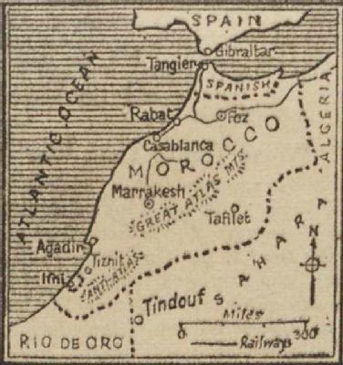
North Africa
Morocco and Spanish territory in North Africa, 1936
This map was published in an unidentified newspaper (probably the Manchester Guardian) on 20 July 1936. It illustrated an article about the initial military rebellion in North Africa, headed 'Spanish Republic fighting grave revolt'.
From the archives of Henry Sara, document reference: 15/3/8/34.